Things to Do at Horseshoe Bend
An overlook walk, a river bend and the canyon country around Page
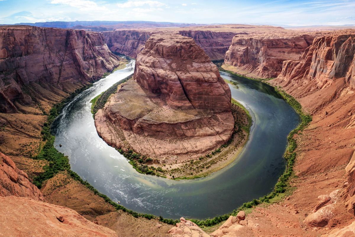
Near the town of Page, Arizona, the Colorado River forms an incised meander shaped like a horseshoe.
- 1.5 miles (2.4 km)Round-trip hike
- About 1,000 feet (300 m)Drop to the river
- 4,200 feet (1,300 m)Overlook elevation
The walk to the overlook
A hardened path carries walkers to the overlook, and the out-and-back distance is 1.5 miles (2.4 km). The Navajo Nation holds the land south of the parking area, including the trail and the overlook.
The trailhead parking lot lies in the City of Page, whereas the overlook itself is inside Glen Canyon National Recreation Area. Horseshoe Bend and that stretch of the Colorado River are part of the recreation area.
The view from the rim
Glen Canyon holds a 270-degree curve at this spot, shaped like a horseshoe and cut roughly 1,000 ft (305 m) deep by the Colorado River. The drop from the overlook down to the river is about 1,000 feet (300 m).
Elevation at the overlook is 4,200 feet (1,300 m) above sea level. Descriptions of the bend call it a superb example of an entrenched meander, and the sandstone at Horseshoe Bend is noted for its crossbedding and iron concretions.
Where the bend sits
From the town of Page, the bend lies about 4 miles (6 km) to the southwest. Measured from Glen Canyon Dam and Lake Powell, it is about 5 miles (8 km) downstream. Grand Canyon National Park begins about nine miles downstream of the bend.
| Reference point | Distance | Relation to the bend |
|---|---|---|
| Town of Page | About 4 miles (6 km) | The bend lies southwest of the town |
| Glen Canyon Dam and Lake Powell | About 5 miles (8 km) | The bend lies downstream |
| Grand Canyon National Park | About nine miles | The park begins downstream of the bend |
The Köppen classification for Page is BWk, an arid climate whose summers are hot and very dry.
How the land took shape
Between six and five million years ago, uplift began across the region and held the Colorado River in its bed. The river then cut down rapidly, and the bend took form. In time the river will likely cut through the neck of the bend, producing a natural bridge and later a cutoff meander.
Over about 300 million years, different environments laid down the sedimentary layers of the Glen Canyon region, mainly sandstones and mudstones. Ancient sand dunes of Jurassic deserts created the sandstone of the area, and it preserves dinosaur tracks.
Theropod dinosaur tracks turn up in the Wingate Sandstone, the Kayenta Formation and the Navajo Sandstone of the Glen Canyon area. Plesiosaur skeletons, carnivorous aquatic reptiles, have been found in the Tropic Shale of Glen Canyon National Recreation Area.
Glen Canyon Dam, Lake Powell and the recreation area
Glen Canyon Dam was completed in 1966, and the flooded Glen Canyon is now mostly submerged beneath Lake Powell. The lake reached full pool in 1980, and at full pool it is 186 miles (299 km) long.
Before the dam of the 1960s and the creation of Lake Powell, most of the central Colorado Plateau and Glen Canyon could not be reached. The nearby town of Page was founded in 1957 as a housing community for Glen Canyon Dam construction workers.
The recreation area that includes Horseshoe Bend covers 1.25 million acres in Arizona and Utah. President Richard Nixon signed the law establishing it on October 27, 1972, and it contains four National Register listed properties.
The Colorado Plateau covers approximately 130,000 square miles across Utah, Arizona, Colorado and New Mexico.
Birds of the recreation area
Glen Canyon National Recreation Area has 315 documented bird species. Only 80 native bird species have been confirmed breeding there, and the area has a harsh climate, bare slickrock and cliffs, and low desert shrub vegetation.
Known water bird species at Lake Powell increased from 32 before 1963 to 83 in 2007. Bare, rocky shores account for over 90% of the Lake Powell shoreline, and few birds were observed along them. Peregrine falcons, delisted in 1999, occupy 80-90% of known nests around Lake Powell and along major rivers each year.
California condors
Habitat destruction, lead poisoning and poaching reduced the California condor population to 22 birds in 1982. The last sighting of a wild condor in Arizona before reintroduction was south of the Grand Canyon in 1924.
Condors were reintroduced to the Glen Canyon area in 1996, when six captive parent-reared birds were released at the Vermilion Cliffs on the Paria Plateau. As of December 31, 2022, there were 561 California condors in existence, almost half of them living in the wild.
Mammals and past records
Desert bighorn sheep in Glen Canyon NRA were reestablished from herds in the Escalante and Canyonlands areas after westwide declines in the 1800s. The gray wolf and grizzly bear were historically found in the Glen Canyon area but were extirpated after Anglo-American settlement.
Some woodrat middens in the Glen Canyon area have been dated to over 50,000 years old, preserving records of past plant and animal communities.
Tours and activities
Tours and activities near Horseshoe Bend
Questions about Horseshoe Bend
Common questions
How long is the walk to the Horseshoe Bend overlook?
The out-and-back distance is 1.5 miles (2.4 km) over a hardened path.
How deep is the bend, and how far is the drop from the overlook?
The Colorado River carved a bend roughly 1,000 ft (305 m) deep, forming a 270-degree horseshoe-shaped curve in Glen Canyon. The drop from the overlook to the river is about 1,000 feet (300 m).
How far is Horseshoe Bend from Page and from Glen Canyon Dam?
The bend is about 4 miles (6 km) southwest of the town of Page and about 5 miles (8 km) downstream from Glen Canyon Dam.
What is the elevation of the overlook?
The overlook is 4,200 feet (1,300 m) above sea level.
Whose land are the trail and overlook on?
The land south of the parking area, along with the trail and overlook, is on the Navajo Nation. The trailhead parking lot is located in the City of Page.
When was Glen Canyon Dam completed, and when did Lake Powell reach full pool?
Glen Canyon Dam was completed in 1966, and Lake Powell reached full pool in 1980.
How many California condors exist today?
As of December 31, 2022, there were 561 California condors in existence, almost half of them living in the wild. Reintroduction to the Glen Canyon area began in 1996.
Sources
- Horseshoe Bend (Arizona)
- Horseshoe Bend - Glen Canyon National Recreation Area (U.S. National Park Service)
- Horseshoe Bend on the Colorado River (U.S. National Park Service)
- Fees & Passes - Glen Canyon National Recreation Area (U.S. National Park Service)
- Page, Arizona
- Park Statistics - Glen Canyon National Recreation Area (U.S. National Park Service)
- Mesozoic Fossils - Glen Canyon National Recreation Area (U.S. National Park Service)
- Glen Canyon National Recreation Area
- Birds - Glen Canyon National Recreation Area (U.S. National Park Service)
- Condors - Glen Canyon National Recreation Area (U.S. National Park Service)
- Mammals - Glen Canyon National Recreation Area (U.S. National Park Service)